The Ridge

Introduction

Alexandrina Plantation LNR and Sandy Lane Public Open Space LNR are situated just to the north of the A52 Nottingham to Derby trunk road, approximately 6km (4 miles) to the west of Nottingham (England), and lies between the suburbs of Wollaton, Bramcote Hills and Lenton Abbey. The Ordnance Survey grid reference is SK 518 386. To map below shows the general area.


Lying towards the southern end of the Greenwood Community Forest, the Open Space covers an area of approximately 12 hectares (30 acres), consisting of a mosaic of acid grassland, naturally regenerating scrub and mature woodland which, through lack of appropriate management in the recent past, has developed into the attractive semi-wild area we see today.

The site lies at the eastern end of a 4km (2.5 miles) sandstone ridge that forms a 'green wedge', connecting open agricultural land in the Trowell/Cossall area with the large urban parkland areas of Wollaton Park and the Nottingham University campus.


To get a really good view of the site and surrounding area, have a go with the embedded dynamic aerial map below


Approximately one third of the site is privately owned and lies mostly within the Nottingham City boundary (shaded red below), with the remainder lying outside the city and mostly owned by Broxtowe Borough Council. However, even with this mix of ownership there is presently unrestricted public access throughout the whole site. THE ownership is depicted on the map below.


The area is also designated as a Grade II SINC, (Site Important for Nature Conservation), and an 'Area of Restricted Development'. It is surrounded on three sides by residential development with a former golf course to the west.

From the outset in 1999, The Friends of Bramcote Ridge originally concentrated their practical management work on the area to the west of the Sandy Lane Bridleway (Alexandrina Plantation LNR). This was primarily because of limited numbers of volunteers and time available. However , since around 2005 they have started to embrace those parts of the site owned by Broxtowe Borough Council, which now form the two distinct Local Nature Reserves.

Geology

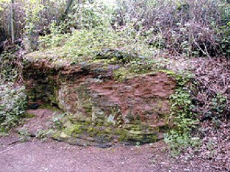
The substrate underlying the Ridge is known as 'Bunter Sandstone Pebble Beds', which is a yellow or buff coloured sedimentary rock, characterised by multi-coloured pebbles embedded in the strata.

These pebbles consist of various types of rock, with quartzite and vein quartz predominating. The term 'Bunter' is of German origin and means 'bright-coloured'.

The Pebble Beds were laid down approximately 246 to 251 million years ago in the Triassic Period when much of the Midlands was a low-lying desert plain. In the Nottingham area, this rock extends to a depth of about 200ft (60m).

In the main the rock is relatively soft and consequently easily cut, however, where the sandstone is cemented by barite it is hard and far more difficult to work. Many of the outcrops throughout the Nottingham area are comprised of this harder stone. There are three sizeable outcrops on the site.

Erosion over the years has created the present low ridge, lying between the 50m and 75m contours (160ft and 245ft), with a predominately north/north-easterly aspect.

The soil is described as 'well drained and coarse loamy soils over soft sandstone' by The Soil Survey of England and Wales (1983) - Classified as 551b Bridgenorth - with a slightly acid average pH of 5.0 and, due to the minimal disturbance, a deep humus layer.

Due to the topography of the site, virtually all water input is via rainfall, which quickly soaks away into the porous bedrock. The 'quick drainage' means that the site is characteristically low in nutrients, as they are leeched straight down into the ground. This is especially true at the top of the site, but water run-off means that the lower areas are slightly higher in nutrients.

For more information about the habits and vegetation found on the ridge, see the Flora page

History

Although very little is known about the history of the site, the general area of Bramcote was enclosed by Act of Parliament in 1771, and the land was put over to (unknown) agricultural use, possibly the grazing of stock.

From contemporary maps, the main woodland area (known as Alexandrina Plantation) appears to have been planted between 1836 and 1880 - possibly to commemorate the marriage of Edward VII to Princess Alexandra in 1863. Many of the older trees appear to have been coppiced at some in the past; possibly during the Second World War, when wood for timber and fuel would have been scarce.


The site was part of Bankfield Farm until the majority of the land was put over for residential development in the 1950's. The Rosegrower public house used to occupy the site of the former farm buildings, however the pub was demolished in 2009 and a care home now stands there.


The Sandy Lane Bridleway, running along the east side of the site, follows the Nottingham City boundary and was once the only route to the village of Wollaton, from the Nottingham/Derby road (the present A52).

On each side of the bridleway are remnants of hedgerows marking the boundary between the parishes of Wollaton and Bramcote. It is believed that these old hedges contain some of the oldest trees and shrubs on the site. Some species of plant inhabiting the hedge banks are usually only ever found on land that has been long associated with woodland.

Throughout the woodland are several sections of old remnant hedgerows, whose location imply that these once formed the boundary of the original plantation, and therefore probably date from the mid 19th century. However since farming ceased, the woodland has crept outside the line of this boundary. These 'hedges' presently exist as either mature standard trees or standing dead wood.

A cast iron boundary marker is located towards the southern end of the Bridleway: this dates from 1933 and commemorates the time when City of Nottingham was extended to incorporate the parish of Wollaton.

Although the Broom scrub in the centre of the site is not of direct historical importance, the name 'Bramcote' is derived from 'cottages in the Broom', and so may be considered to be indicative of the area long ago when the first Anglo-Saxon settlers arrived in the area.

Since the late 1950's, when the surrounding residential development began, the local community has enjoyed open access to the land to the west of the bridleway and over time has become a much valued local amenity, being frequently used by residents as a recreational amenity - primarily for walking, cycling, dog exercise and 'adventurous play'.

However access to the land to the east of the bridleway came much later - the area currently owned by Broxtowe Borough Council was, until the mid 1970's, part of Lowes Nursery: who specialised in roses. The section that falls within the city boundary used to be completely fenced off, but over time the fences have fell into disrepair and now numerous informal paths criss-cross the site.


Broxtowe Borough Council realised the value of the area as a recreational resource and the whole ridge was designated as an 'Area of Restricted Development' in 1975. This has safeguarded the area against further development and maintained the Ridge for recreation. It was this document that proposed that the area should 'be conserved in its wild state'.

A review of the plan in 1981 proposed the repair of eroded rights of way on the site. Also, it proposed that an access agreement should be sought with the owner of the northern section - no evidence of any agreement has been found. The 'Broxtowe Local Plan' (1994) re-affirmed the commitment to preserve the area in its wild state as a recreational amenity, and recognised the environmental and ecological importance of the site.

The next major event in the history of the Ridge came in April 1999, with the formation of The Friends of Bramcote Ridge, and any developments since this date are detailed elsewhere on this Web Site. Working to management plan for the area known as Alexandrina Plantation, created by one of the Friends's founding members, the friends set about caring for the site. A counterpart management plan for the area now known as Sandy Lane Open Space was produced a year later.

In 2005, Browtowe Borough Council made a Declaration that created two Local Nature Reserves on the Ridge, namely Alexandrina Plantation LNR and Sandy Lane Open Space LNR.

Visiting the Ridge

How To Get Here

Approaching from the West - from junction 25 of the M1, follow the A52 towards Nottingham. Go straight on at the first two traffic islands, eventually passing Bramcote Hills Leisure Centre on the left. Continue along the three-lane dual carriageway for approximately ¼ mile, and turn left at the first traffic light junction - this is Thoresby Road. Please read the note below concerning parking.

Approaching from the East - leave Nottingham on the A52 heading towards Derby. Go straight on at both traffic islands, and continue along the dual carriageway. After approximately one mile, just after the Total petrol station, take the first right turn (traffic lights) onto Thoresby Road. Please read the note below concerning parking.

Wheelchair access is available from the top of Sandy Lane, where a 400 metre (440 yard) surfaced path has been installed. - this leads gradually to the highest point on the Ridge - from where there are extensive views over western Nottingham.

Please Note: there is no formal car park, but limited parking is available on residential roads at, or near to, the numerous access points - the map below shows their locations.

Parking on Thoresby Road will restrict traffic flow and is therefore not recommended.

The immediate area is covered by both OS Landranger Sheet 129 and Explorer Sheet 260.

To view a large scale map of the entire open space Click Here. This page may take a while to open, so please be patient!